 Picture: Schiebel Coorporation
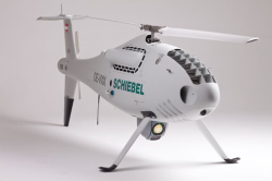
Since 2006, the Vienna-based Schiebel Coorporation has been perfecting and manufacturing an award-winning unmanned air vehicle (UAV or “drone”).
Engineered to aviation standards for use on sea or land, the 3.5-metre long Camcopter S-100 includes sophisticated features such as fully autonomous flight and vertical takeoff and landing capabilities.
The CAMCOPTER® S-100 has the ability to complete an entire mission automatically and with zero operator intervention, or it can be reprogrammed at any time when airborne to perform alternative missions or react to task changes.
Programming for an autonomous mission is controlled via a simple point-and-click graphical user interface with payload imagery transmitted to the Control Station (CS) in realtime. Redundant Inertial Navigation Systems (INS) and Global Positioning System (GPS) ensure highly accurate navigation and stability.
In the case of loss of link, an automatic home point function is activated.
The Camcopter S-100 has been certified for flight by both the Austrian AustroControl (ACG) and the European Aviation Safety Agency (EASA) and is now Schiebel’s lead product.
Possible applications for the CamCopter in the civil arena include:
In addition to its general image capturing capabilities, the Camcopter S-100’s payload potential includes:
- Communications Relay
- Transponder
- Loudspeaker
- Pamphlet, smoke or rope-dropping containers
- Synthetic Aperture Radar (or SAR, a form of radar used to create images)
- Ground Penetrating Radar (GPSAR, used to image sub-surfaces)
As new legislation around drone technology is being drafted in different parts of the world, Schiebel stands behind this cutting edge product for a myriad of civil uses and offers full training and operating support services.
